Monday October 1, 2012
We left Solomons Island early in the morning & headed for Deltaville, VA. Dave had heard of Dozier’s Regatta Point Marina. We thought we would try it since it would make a shorter run to Norfolk, VA the next day. It was the nicest marina we’ve been to so far! It was cheap, beautifully landscaped, clean, & had lots of facilities. The marina owner is the publisher of the Waterway Guides & the Skipper Bob publications.
Tuesday morning we left for Norfolk, we got about an hour south on the Chesapeake. The wind was gusting to 15 knots coming out of the south, the current was coming in and and the waves were about 3 foot. We decided that this was not going to be a fun sail and turned around and went back to Dozier’s Marina.
The weather conditions were the same Wednesday so we stayed again. We borrowed their courtesy car & went into Deltaville & did errands. Dave got his first hair cut since being away. It turned out okay, even though he was warned not to get a certain lady. We spent the afternoon doing odds & ends on the boat.
We decided to try going to Yorktown to Riverwalk Landing Marina. As we were approaching Riverwalk, Dave saw a dolphin off the stern of the boat. This was the closest we’ve been to them! We are finding the guide books have a tendency to embellish the facilities. Riverwalk had no wind protection, & there was a good foot & a half swell in the harbour, plus nothing was close-by to see. So we left & got a slip in a marina across the York River. The only attraction we ended up seeing was a Wal-mart Supercentre - our first since leaving Port Elgin.
Friday morning we left for Norfolk, VA. We were able to sail part way down the York River to the Chesapeake Bay. Then the winds died & we just motored the rest of the way. Norfolk is the world’s largest naval facility & it is huge! We saw 4 or 5 aircraft carriers plus numerous other large naval vessels, which we had no idea what they were. These were all being protected by helicopters, small patrol boats & jet fighters. Needless to say, we didn’t go for a close up look. We ended our day at Waterside Marina, about 6 miles north of the start of the Intracoastal Waterway.
The next morning we headed south to the start of the ICW in the rain. After going through the Gilmerton Highway Bascule Bridge, we left the military/industrial area of Norfolk & entered a rural creek on our way to the Great Dismal Swamp Canal. There’s a lock at both ends of the canal that maintain the water level 8 feet higher than the waterway in & out of the canal. The canal was dug by hand, by slaves & is maintained at a minimum depth of 6 & half feet. The depth sounder showed between 6 & a half feet & 8 & a half feet, but we still managed to find a dozen spots to polish the bottom of the keel. We stopped at the Visitor’s Centre for the night & tied to their dock. Also checked out the Dismal Swamp State Park Visitor’s Centre on the other side of the canal.
 |
| Time 2 Go at the Dismal swamp Canal Visitor's Centre |
 |
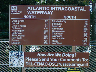
| Places we've been and places still to come |
 |
| Pasquotank River after leaving the Dismal Swamp Canal |
 |
| Tannin coloured water trail |
 |
| Duck weed covers the whole Pasquotank River the wild life don't seem to mind but tough on cooling water strainers |

No comments:
Post a Comment